METEOROLOGY 360
Fall, 2014
Exam 1
Directions:
Answer all parts of all questions in the blue books or in a text
file unless otherwise
directed, as in 1c and 1d. For calculations, show all work.
You may use any source, including your notes, any textbook or
the
Internet. You may NOT talk during the
exam, except to me. Raise your hand if
you have a question.
The following
information may (or may not) be
useful:
1. The following map may also be found (in color) at this link:
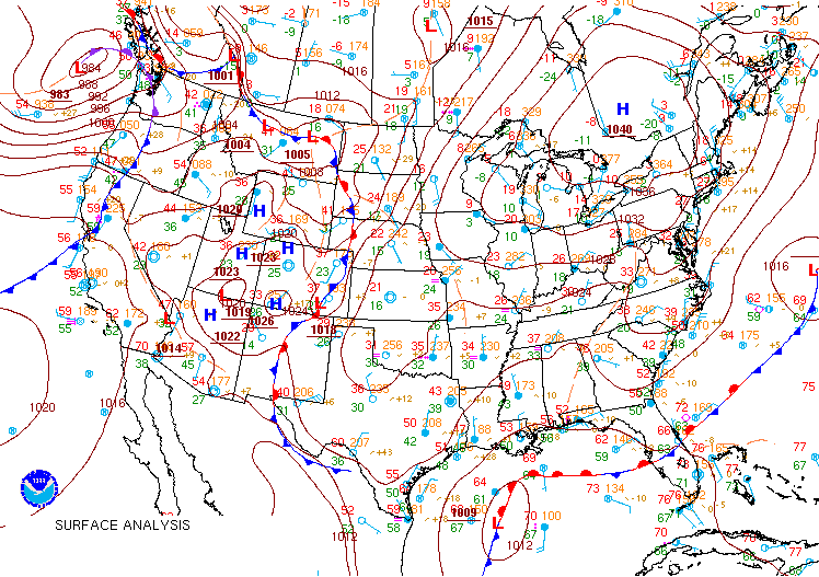
a. ( 5%)
This is an actual late winter situation.
There is an inverted trough on this surface map.
On your printed map (above), label it in an obvious
way (such as Inverted trough  ).
).
b. ( 6%) Is the front in the Gulf of Mexico strong or weak? Give two reasons to justify your answer. Note: It doesn’t matter if you pick strong or weak but your reasons must be valid to support that answer.
c. ( 15%) On the three maps shown below you are to draw the weather situation that would be expected if the Low in the Gulf of Mexico develops the way Bjerknes and Solberg envisioned in their “Norwegian Model”. Draw only fronts, centers of Highs, and centers of Lows. Use the standard symbols. Color is not necessary. The first map is 12 hours after the initial map above. During these 36 hours after the initial map, assume the next three phases of the Norwegian Model occur, one per map. Include a second low in the proper place and time.
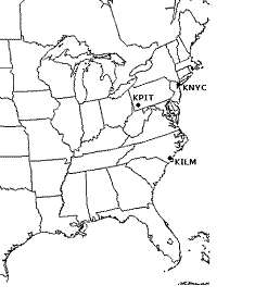

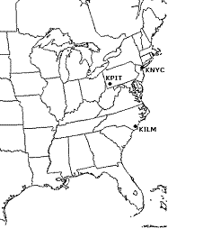
12 hours 24 hours 36 hours
d. ( 30%) There are three cities shown. In the table below, write forecasts of temperature (T), wind direction (W), and precipitation type (P) for the three map times shown. Your forecasts must be consistent with the maps you drew.
|
12
hours |
24
hours |
36
hours |
|||||||||
|
T |
W |
P |
T |
W |
P |
T |
W |
P |
|||
|
KNYC |
|||||||||||
|
KPIT |
|||||||||||
|
KILM |
|||||||||||
2. The following 12Z NAM initialization maps for the same situation of question 1 may be relevant to this question: MSLP, 500 mb, 300 mb. Assume all are perfect representations of the atmosphere at 12Z on that day.
a. ( 5%) The wind at NYC on the 300 mb map looks like this: ![]() The
wind direction is 265º. If you were
coding this for upper air code,
what would the wind group be?
The
wind direction is 265º. If you were
coding this for upper air code,
what would the wind group be?
b. ( 3%) On the NAM MSLP initial map, what is the blue dashed line marked “540”?
c. ( 4%) Compare the NAM MSLP with the 500 mb map. The patterns of the dashed colored lines and solid black lines look similar. Why should you expect them to be similar?
d. ( 4%) Again, comparing the the NAM MSLP with the 500 mb map, why should you expect the labels on the lines to be different?
e. ( 6%) On the 300 mb or 500 mb map, above the MSLP High in the northeast U.S and southeast Canada why is the ridge so small and of a very weak amplitude?
3. For this question, refer to the Albany sounding shown at this link.
a. ( 6%) Why does the lowest 150 mb of this sounding consist mostly of an inversion layer? To support your answer give two observations from the sounding only.
b. ( 6%) What is the Convective Temperature at Albany on this day? Briefly explain how you got your number.
c. ( 10%) There is an elevated stable layer which goes from 4000 meters at 630 hPa to 5000 meters at 560 hPa. Assuming 630 hPa is the top of a cool air mass with its front 1500 kilometers away, what is the angle that front makes with the ground (in degrees)? Show your work. Draw a picture to illustrate this situation and the angle. (Note: you have all the information you need)