METR 360
Fall, 2018
Exam 2
Directions: Answer all
parts of all 5 questions in the blue books or write a text file which you
e-mail to Jerome.Blechman@oneonta.edu. For calculations, show
all work. You may use any source,
including your notes, any textbook or the Internet. You may NOT talk during the exam, except to
your professor. Raise your hand if you have a question.
The following information may (or may not) be useful:
1.This is a question about lake effect. You have a surface analysis, a surface station plot map, the 850 mb map, and the GLSEA analysis.
To
see where the cities in this question are located, click here.
a. ( 5%) Suppose
you are employed by a Great Lakes shipping company and need to alert drivers of
heavy lake effect snow on January 5. Should you alert the branch in Cleveland,
OH? Why or why not?
b. ( 5%) Your
company also has a branch in Muskegon, MI.
Will the trucks driving to or from Muskegon get heavy lake effect
snow? Why or why not?
c. ( 5%) Your company even has a
branch in Duluth, MN. What do you tell
them about lake effect there? As before, briefly explain your answer.
2. You are given two 500 mb maps, plotted but analyzed only for height lines, 500 mb map 1 and 500 mb map 2.
( 4%) For each of these two maps, in one word (each), how would you characterize the flow patterns? Use the terminology we learned in class for both these types of flows. So, write these in your file or blue book and fill in the blanks: The Map 1 flow is ____________ The Map 2 flow is ______________
a. ( 10%) Starting from the GFS 500 mb initialization map for 00Z Oct 28 and assuming the trough in the Gulf of Alaska (centered at approximately 130°W in longitude) and ridge in the western U.S. are a single wave, calculate the wave’s speed. Assume the mean west-east wind is 40 kts and the mean latitude is 46°N. Use the initialization map for other needed data not given here. You may also want to check the possibly useful information at the start of this exam.
b. ( 5%) Based on the wave traveling at the speed you calculated from part a, would it be considered a short wave or a long wave? Briefly justify your answer to a meteorologist.
c.
( 6%) For the same 500 mb initialization map
and latitude, if there had been a trough in the Gulf of Alaska with a trough
length (not wavelength) of 3575 km with the same other characteristics
as in part a, would the wave movement be eastward or
westward? At what speed?
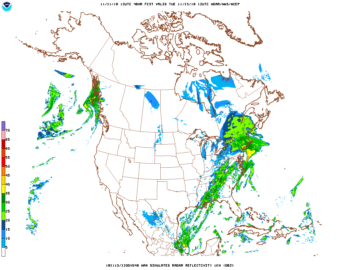
4. If the NAM forecast initialized at 12Z on Sunday November 11 is correct, we had a big storm yesterday. Study the forecasts for MSLP/Thickness, 2m wind/precip, 2m wind/temp (with close-up), simulated radar, 850 mb height/temperature/wind flags (with close-up), 700 mb height/RH/vertical velocity (with close-up), 500 mb height/η (with close-up). You also have the forecast sounding for south-central Long Island from Twisterdata.com. All maps verified at 12Z on Tuesday November 13.
a. ( 6%) The vorticity forecast map shows a small maximum over western Long Island (the purple color surrounded by yellow and orange in the closeup). What is the value of that vorticity, based on the scale in the full map? Include units and write your answer in scientific notation with the proper scaling factor.
b. ( 4%) If the latitude of the vorticity maximum in part a is 40.7°N, what is the value of the forecast relative vorticity at that location and time? Don’t overthink this. Use your answer to part a.
c. ( 7%) We learned the three causes of vertical motion on the synoptic scale. Pick the vertical motion mechanism you see acting the most powerfully in this case and in the location of maximum upward vertical motion shown on the 700 mb forecast map and closeup. Identify it and explain what you see on the forecasts that justifies your choice. Use as many forecast maps as you need for your justification.
d. ( 3%) What is the maximum value of
vertical motion shown on the 700 mb forecast map and closeup? Include units.
5. For this question you need to use the numerical guidance from models initialized at 12Z on November 3. You have MOS guidance for both NAM and GFS. All guidance is for Kansas City, Missouri, KMKC. Click here for a map showing the location of KMKC.
a. ( 4%) There are two precipitation events that occur during the first 84 hours after 12Z on Nov 3. What kind of “present weather” is most likely to cause the precipitation in the first event? I’m not asking for a synoptic weather map feature. Present weather is used in the sense of what would be reported on the KMKC METAR. This is a short answer. You can use a symbol, the METAR reporting element, or just write it out in words.
b. ( 8%) Based on the GFS guidance, at what times/dates will precipitation most likely begin and end for both events? You must have four answers, each with a time/date.
c. ( 4%) How much precipitation is projected to fall in the first event? This is a range, in hundredths of an inch.
d. ( 4%) The Nov 4 maximum temperature is different on the NAM forecast (49°F) than on the GFS forecast (53°F). Give the most likely reason why they are different, referring directly to one of the other MOS forecast parameters.
e. (20%) On the paper map supplied with KMKC marked, draw a surface prog for 03Z on Nov 4 (note: we don’t usually get 03Z progs but you are to draw one anyway), based solely on the GFS MOS forecasts. You must draw Highs, Lows, and fronts, using the standard symbols. Draw some isobars also to provide a sense of the pressures and gradients. Label your isobars with reasonable pressures for this situation. You must also plot a station report on the circle shown for KMKC. Use the standard plotting model. Include as much information as you can get from the GFS MOS guidance. Be sure you are plotting the forecast 03Z Nov 4 data.