METR
360
Fall,
2017
Exam
2
Directions: Answer all parts of
all questions in the blue books or write a text file which you may e-mail to Jerome.Blechman@oneonta.edu. For
calculations, show all work. You may use any source, including your
notes, any textbook or the Internet. You may NOT talk during the exam,
except to me. Raise your hand if you have a question.
The following information may (or may not) be useful:
1. For the
last forecast for Salt Lake City in WxChallenge you should have viewed the
following MOS and direct model outputs:
GFS MOS (MAV)
KSLC
GFS MOS GUIDANCE
11/02/2017 1200
UTC
DT /NOV 2/NOV
3
/NOV
4
/NOV 5
HR 18 21 00 03 06 09 12 15 18 21 00 03 06 09 12
15 18 21 00 06 12
N/X
58
70
51
65 44
TMP 65 69 68 61 61 61 62 62 65 65 62 55 53 54 54 57 61
59 55 49 46
DPT 39 36 36 38 38 39 40 41 42 39 38 39 37 36 36 37 36
34 35 37 38
CLD OV OV OV OV OV OV OV OV OV BK BK OV OV BK BK OV OV
OV OV OV OV
WDR 18 19 16 16 16 16 16 16 18 22 29 15 16 16 16 16 19
22 31 34 14
WSP 14 14 11 12 16 21 23 19 21 15 11 10 15 15 15 16 21
21 15 05 07
P06
0 7 18
30 20 14
11 14 24 41 42
P12
19
31 16
30 53
Q06
0 0 0
0 0 0
0 0 0 1 1
Q12
0
0
0
0 1
T06 2/ 0 1/ 0 2/
0 2/ 0 2/ 0 1/ 0 1/ 0 1/ 0 4/ 0 2/ 0
T12
2/ 0 2/
1 2/
1 1/ 0 4/
0
POZ 0 0 0 0 0
0 0 0 0 0 0 0 0 0 0
0 0 0 0 0 0
POS 6 0 0 2 4 15 15 11
16 8 10 8 13 23 34 15 16 8 6 33 38
TYP R R R R R
R R R R R R R R R R
R R R R R R
SNW
0
0
0
CIG 8 8 8 7 8
7 7 7 7 7 7 7 8 8 8
8 8 8 7 7 7
VIS 7 7 7 7 7
7 7 7 7 7 7 7 7 7 7
7 7 7 7 7 7
OBV N N N N N
N N N N N N N N N N
N N N N N N
NAM MOS (MET)
KSLC
NAM MOS GUIDANCE
11/02/2017 1200
UTC
DT /NOV 2/NOV
3
/NOV
4
/NOV 5
HR 18 21 00 03 06 09 12 15 18 21 00 03 06 09 12
15 18 21 00 06 12
N/X
52
59 46
56 40
TMP 62 66 65 64 64 64 63 52 55 56 54 51 50 50 49 49 52
53 50 45 43
DPT 37 35 35 34 35 36 37 40 41 39 38 38 37 37 38 35 36
35 35 36 36
CLD BK BK OV OV OV OV OV OV OV OV OV OV OV OV OV OV OV
OV OV OV OV
WDR 20 23 21 16 16 16 16 17 17 19 19 16 17 16 17 17 17
19 18 19 18
WSP 08 10 09 13 19 21 23 22 21 18 13 09 12 17 18 17 18
15 15 14 11
P06
1 1 7
32 20 6
2 3 16 39 57
P12
7
47
6
32 57
Q06
0 0 0
0 0 0
0 0 0 1 3
Q12
0
1
0
0 2
T06 1/ 2 2/ 0 1/
0 2/ 1 2/ 0 1/ 1 0/ 0 1/ 2 3/ 2 12/ 2
T12
2/ 2 2/
1 2/
1 1/ 2 17/ 2
POZ 0 0 0 0 0
0 0 0 0 0 0 0 0 0 0
0 0 0 0 0 0
POS 6 4 1 0 7
1 5 5 9 8 14 19 12 11 14 16 12 14 12 22 34
TYP R R R R R
R R R R R R R R R R
R R R R R R
SNW
0
0
0
CIG 8 8 8 7 8
7 6 6 6 6 7 7 7 7 7
7 6 7 6 6 6
VIS 7 7 7 7 7
7 7 7 7 7 7 7 7 7 7
7 7 7 7 7 7
OBV N N N N N
N N N N N N N N N N
N N N N N N
NAM Direct Model Output
Station: KSLC Lat:
40.78 Lon:-111.97 Elev:1286 Closest grid pt: 18.3 km.
Initialization Time: 17-11-02 1200 UTC
PARAMETER/TIME
000 006 012
018 024 030
036 042 048
------------------- ------ ------ ------
------ ------ ------ ------ ------ ------
DAY /
HOUR 02/12 02/18
03/00 03/06 03/12 03/18 04/00 04/06 04/12
------------------- ------ ------ ------
------ ------ ------ ------ ------ ------
TEMPS
2 M
(F)
52 52
46 42
42
42 39 37
850 MB
(C)
12 15
11 8 8
9 7 6
700 MB
(C)
1 2
3 -1 -3
-3 -4 -4
500 MB
(C)
-15 -15 -16
-16 -16 -16 -18
-18
1000-500
THCK
559 562 559
555 554 554
552 550
MOISTURE
2 M DEW POINT
(F)
34 34
40 40
39 36 32
34
850 MB
DP(C)/RH
3/54 3/44 7/78 7/95
7/90 5/77 3/76 4/90
700 MB
DP(C)/RH
-7/58 -3/67 -3/66 -1/94 -3/96 -4/97
-4/96 -7/76
500 MB DP(C)/RH
-18/75 -18/77 -18/87 -34/19 -35/18 -28/34 -22/72 -26/52
PRCPABLE WTR
(IN) 0.38
0.49 0.55 0.47 0.42
0.41 0.43 0.38
CONV PRECIP
(IN)
0.00 0.00 0.00 0.00
0.01 0.01 0.00 0.00
TOTAL PRECIP
(IN) 0.00
0.00 0.00 0.01 0.04
0.03 0.01 0.01
WIND DD/FFF (Kts)
10
M
23/010 19/007 18/015 19/014 21/013 21/009 19/010 19/011
850
MB
24/009 19/008 19/015 19/013 21/012 21/009 20/009 19/011
700
MB
26/025 22/022 22/023 22/026 22/024 21/024 22/026 23/029
500
MB
27/050 26/047 24/039 24/039 25/041 25/043 25/048 24/057
250
MB
27/075 26/076 24/080 25/084 25/088 25/103 25/108 24/094
PRESS/HEIGHTS
MSL PRESSURE
1010.2 1006.5 1010.4 1011.8 1012.2 1010.6 1013.3 1012.6
850 MB
HGT
147 145 146
146 147 145 146
145
700 MB
HGT
306 305 305
303 304 303 303
301
500 MB HGT
568 568 568
564 564 562
563 560
250 MB
HGT
1056 1057 1055 1050
1048 1047 1046 1042
VERTICAL VEL (uB/S)
850
MB
29 -6
-21
-3 18
17 -2 -13
700
MB
55 4
17 48
52 16
18 21
500
MB
-34 13 -2
-18 -9
3 -8 -3
GFS Direct Model Output
Station: KSLC Lat:
40.78 Lon:-111.97 Elev:1286 Closest grid pt: 18.3 km.
Initialization Time: 17-11-02 1200 UTC
PARAMETER/TIME
000 006 012
018 024 030
036 042 048
------------------- ------ ------ ------
------ ------ ------ ------ ------ ------
DAY /
HOUR 02/12 02/18
03/00 03/06 03/12 03/18 04/00 04/06 04/12
------------------- ------ ------ ------
------ ------ ------ ------ ------ ------
TEMPS
SFC (2 M)
(F) 43
53 53
46 45
49 48
42 39
850 MB
(C)
10 14
15 11
10 11 12
9 7
700 MB
(C)
2 1
2 2
0 -2
0 -1 -2
500 MB
(C)
-15 -15 -15
-15 -16 -17
-16 -17 -19
1000-500
THCK 558
559 561 559
556 555 556
555 552
MOISTURE
30 M AVG
RH
67 56
47 67
82 68 60
54 64
850 MB
DP/RH 6/73
4/53 4/46 5/66 7/80
5/64 4/59 1/57 1/66
700 MB
DP/RH -6/56 -5/64 -2/74
-3/71 -2/89 -3/93 -3/81 -5/70 -7/68
500 MB
DP/RH -24/46 -17/86 -17/86 -20/70 -29/33 -22/62
-27/38 -19/85 -23/70
CONV PRECIP (IN)
TOTAL PRECIP
(IN) 0.00
0.00 0.00 0.03 0.03
0.03 0.00 0.00
WIND DD/FFF (Kts)
30 M
AVG 20/013 22/011 20/009
19/017 19/018 21/016 22/006 19/015 19/013
850
MB 18/009
22/009 20/006 18/012 19/013 21/014 22/004 18/010 18/008
700 MB
25/020 24/021 22/022 22/025 22/027 22/023 22/022 22/027 23/026
500
MB 28/055
26/047 26/046 24/038 24/038 24/036 25/040 25/046 24/051
250
MB 28/082
27/076 26/076 25/077 25/081 25/079 25/097 24/104 25/095
VERTICAL VEL (uB/S)
850
MB
18 0
-17 -9
23
14 -14 -21
700
MB
44 27
38 35
35
55 35
46
500
MB
-18 6
-10 -9 -12
-25 3
7
OTHER
MSL PRES
(MB) 1008 1010
1009 1011 1011 1011
1009 1011 1009
500 MB HGT
(DM) 565 568
569 569 565
565 564 564
561
500 MB ABS
VORT 6.8 4.6
9.2 4.9 12.9 12.6
13.5 8.4 11.8
The
verification for November 3 was Max: (64°F) Min: (48°F) Wind (24 knots) Precip:
0.01" In comparison, the verification for November 2 was (72°F) Min:
(49°F) Wind (23 knots) Precip: 0.00"
a. ( 5%)
The GFS and NAM MOS forecasts were very different and both wrong. Other than N/X, what guidance shown on
this exam was consistent with cool surface temperatures at KSLC that would max
out at 64°F on November 3? Note: I’m not asking for your own personal forecast. Look at this guidance (MOS and Direct Model
Output) only.
b. ( 9%) It rained at KSLC! It was only 0.01” but only one person on the
NYO team (Delaney) went for nonzero precipitation. What three (3) predictions other than TOTAL
PRECIP (IN), shown on the Direct Model Output only were consistent with measurable
(>0.00”) precipitation at KSLC in the period from 06Z Nov 3 to 06Z Nov 4? Be specific about what parameters you are
picking and what day/time these occurred. You do not have to explain why you
picked them or how they worked. And you may pick any combination of parameters
from GFS and NAM Direct Model Output (e.g. 2 from GFS and 1 from NAM or 0 from
GFS and 3 from NAM, etc.)
c. ( 16%) Describe the weather (temperature, humidity, precipitation) that was
forecasted to be experienced at KSLC from 06Z November 3 to 06Z November 4. Write two separate descriptions, one for the
forecast by the NAM model and one for the forecast by the GFS model. Relate
each of those two descriptions to surface weather elements which
would fit. For example, was there a
frontal passage at the surface? If so,
describe what kind of front, when it would pass, and what the effects would
be.
2. For this
question, refer to the series of 500 mb
maps from October 2016, shown in a PowerPoint file.
a. ( 6%) The trough axis travels from KUIL (Quillayute!) to
KBOS (Boston) in exactly three days or 72 hours. Using a GoogleMaps product, those two NWS stations are 2567 miles
apart. What is the speed of that trough for those three days? Do not
use the Rossby wave equation. Express your answer in m s-1.
Show your work for the calculation.
b. ( 3%) Using your answer to part a, was that wave
progressive, retrograde, or blocked? Short answer
c. ( 8%) Again, using
the speed you calculated for part a, if the latitude of the wave was 49°N, what
was the mean west-east wind speed across the U.S.? For this you use the Rossby wave
equation. Express your answer in knots.
Show your work for the calculation.
d. ( 5%) While the wave was in the midwestern U.S. at 00Z on Oct 13, 2016, the winds were around 60 knots from 270° in central Illinois. That was probably different from your answer to part c. Briefly explain why, assuming that both your calculations and the observed 60 knot wind were correct.
3. This is a
question about the situation on October 24, 2017. You have a small CONUS map, a large North American map, and the 850 mb, 700 mb, 500 mb, and 300 mb maps.
a. ( 3%) On the 850 mb map,
KALB is reporting a south wind at 65 knots with a temperature of 12°C. Does
this situation mean cold air advection, warm air advection, or neither?
b. ( 6%) Is the flow at 300 mb
zonal, meridional, or neither? Why did you choose that answer?
c. ( 5%) The 500 mb map shows
heights and vorticity. There is a Low (marked L) over northern Lake Michigan. What is the maximum
value of vorticity associated with that Low? You may need to magnify the
map to see it. Use the correct units and scaling.
d. ( 6%) Describe the vertical tilt of the storm that is shown at the Great
Lakes at the surface. This need not be quantitative, but you must refer to
locations on the upper air maps and specify the direction of the tilt from map
to map up to 300 mb.
e. ( 6%) Considering the tilt you described in part d, how does that tilt affect the weather at the Earth’s surface? Be as specific as you can. Hint: look closely at the CONUS to see the weather being reported.
4. This
question refers to a closeup 500 mb
map with stations plotted but not analyzed for isopleths. Stations A,
B, C, and D are shown with observations which have been embellished for this
question only. A and B are 400 km apart. C and D are also 400 km
apart. The fictional station KNYX is located directly in the middle,
where lines connecting A to B and C to D would intersect. KNYX is at
42.5°N.
a. ( 8%)
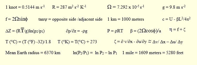
Using the information given, calculate the relative vorticity (ζ) and
absolute vorticity (η) using the correct units. Show your work.
Watch your signs!
b. ( 3%) What
type of vertical motion would be associated with your answer to part a?
Short answer
5. For this
question you have a 12Z CONUS surface
map, the North America
Zoom-in map, the 12Z 850 mb map,
and a lake surface temperature map.
a. ( 5%) Name
the areas which are likely to be receiving lake effect precipitation from the
Great Lakes (e.g., northern Wisconsin, southern Michigan, Pennsylvania
and New York, etc.).
b. ( 6%) List the factors that were
present that were favorable for lake effect precipitation in the areas you chose
for part a.