METR 360 Fall, 2015 Final
Exam
Directions: Answer all
parts of all 6 questions. Use the blue
books or write a text file where required. Draw on the paper copy of the exam
where requested. For calculations, show all work. You may use any source, including your notes,
any textbook or the Internet. You may
NOT talk during the exam, except to me.
Raise your hand if you have a question.
The following information may (or may not) be useful:
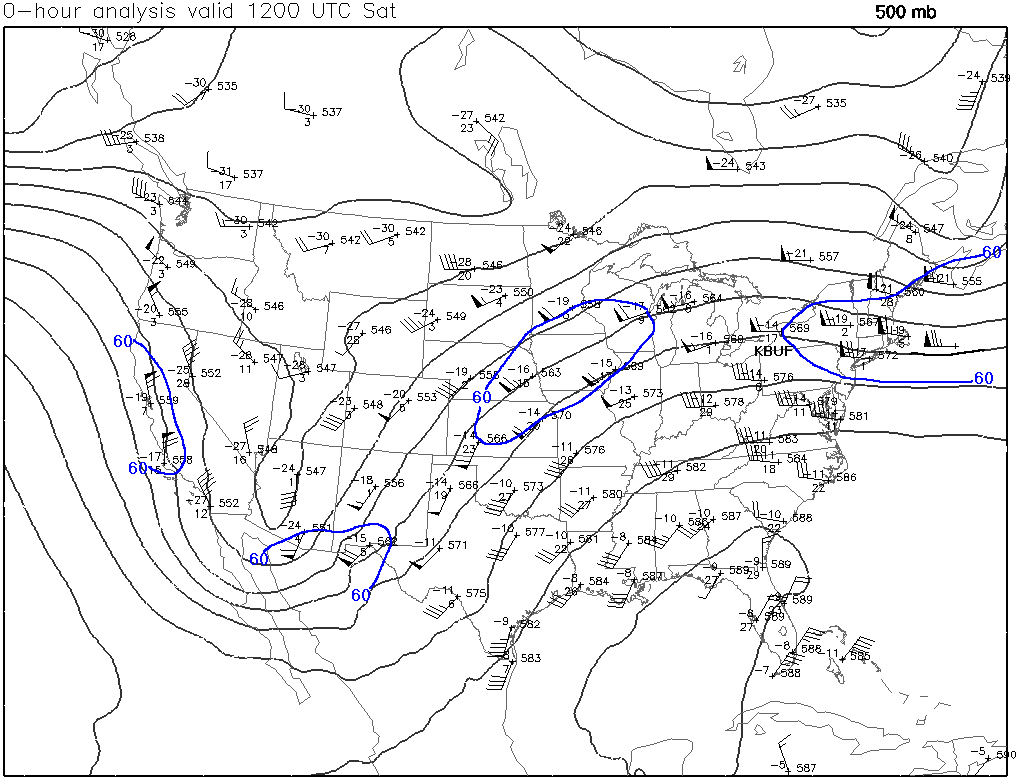
1. For this question, use
the 500 mb map at this link. This map has been analyzed for heights in
black and the 60 knot isotach in blue.
Answer the following:
a. ( 6%) Data
from the radiosonde released from Buffalo, NY are shown over the designation
KBUF on the map. List the 500 mb
temperature, dewpoint, and height above mean sea level, using the proper units.
b. ( 4%) On the
paper version, where appropriate, label all Entrance and Exit regions. Note:
On this map, not all jets will have both. You decide.
c.
( 4%) Again, on the paper version, for the Entrance and Exit regions draw solid
black arrows to represent the ageostrophic wind directions (do not draw the
geostrophic wind directions).
d.
( 4%) What will be the net effect of the ageostrophic winds on the eastern
ridge only from the jet centered on Iowa? Briefly justify your answer.
2. For this question, a PowerPoint
loop of surface progs has been created. The PowerPoint file allows you to
see the individual frames or step through the frames to see changes. Note that
the location of Green Bay, WI is marked KGRB on the first map.
( 12%) Write a forecast for KGRB that is consistent with this
series of progs and the classic features of the Norwegian Model. Specifically, forecast relative temperatures
(warm, hot, cool, arctic, etc), precipitation types, and the cloud types at
each time shown by the progs. Use the
times shown at the bottom of each prog.
In the blue books or text file, list them like this:
12Z
Saturday: (in the blue books or text file, write your answers on each line)
00Z
Sunday:
12Z
Sunday:
00Z
Monday:
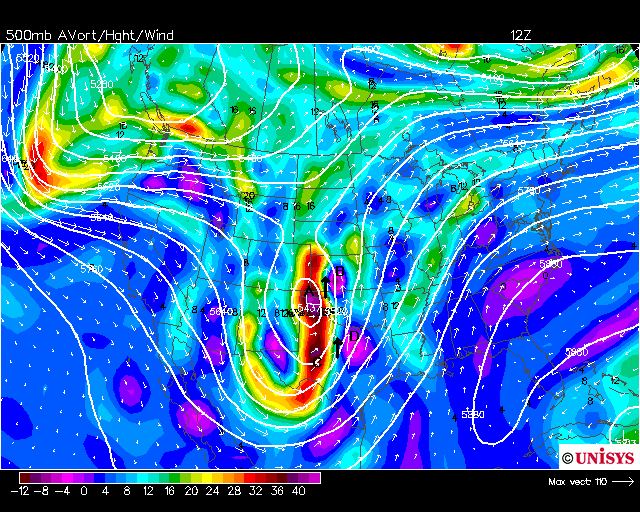
3. This question refers
to the NAM 500 mb initialization loop starting from
12Z Nov 26, 2015 with forecast maps out to 48 hours. The wave which initially
is centered on 40°N has a measured wavelength of 2277 miles which is 3.6635 x
106 meters. Show your work in a logical progression and finish with
the answer, including the units. If you
change units, you must show how.
a.
( 6%) If we were to consider the entire wave across North America to be
stationary for the 24 hours of the loop, what would be the mean west to east
wind at 500 mb?
b.
( 6%) The waves are not stationary everywhere.
For the latitude of 60°N (in Canada), compute the actual wave speed
using the mean west to east wind you found for part a. Then do the same for a latitude of 30°N
(across the southern U.S.).
c.
(12%) Using the loop and your other answers for this question, portray in one
line each (a total of three lines), the wave types and motions across the U.S.,
Canada, and the Caribbean Sea area (40°N, 60°N, 30°N in that order) for the
duration of the loop using appropriate terminology for a meteorologist.
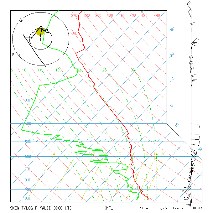
4. For this question,
click the link for a Miami, FL (KMFL) sounding taken at
00Z on an unspecified day in the last four weeks.
a. ( 6%) List
three separate reasons why the atmospheric conditions at 00Z are unfavorable
for precipitation.
b. ( 3%) Is
there anything at all on this image that tells you there is a possibility for
precipitation? List just one aspect that
is favorable.
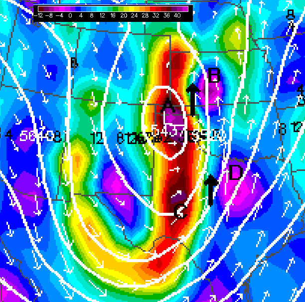
5. The 500 mb map shown here
is a 12Z depiction. Four vorticity
centers are labeled A, B, C, and D. The
labels are offset slightly from the centers so you can see the colors better. There is a zoom-in
version to help you even more.
a.
( 8%) What are the maximum/minimum vorticity values at the places nearest A, B,
C, and D? Use the correct units.
b. ( 4%) Based
on the size of the white arrows, two jet streak locations are marked with heavy
black arrows. Briefly explain why the
centers A and B straddle one of those jet streaks and centers C and D straddle
the other. Both answers are the same so
you may write it just once.
c. ( 4%) The
white arrows are almost perfectly straight between A, B, C, and D. Why are the vorticity values on the west side
of the black arrows much greater than the values on the east side? There are
two reasons. List them both (do no
calculations).
6. Here is a series of
MOS forecast data for Minneapolis, MN, based on the NAM run at 00Z on December
12, 2015
KMSP NAM MOS GUIDANCE 12/12/2015
0000 UTC
DT /DEC 12
/DEC 13 /DEC 14
/
HR
06 09 12 15 18 21 00 03 06 09 12 15 18 21 00 03 06 09 12 18 00
X/N 40 35 43 31
33
TMP
36 35 34 34 38 39 38 38 38 37 37 38 40 42 39 37 35 34 33 32 29
DPT
31 31 30 31 32 33 33 33 33 34 34 34 36 37 36 33 31 30 29 27 25
CLD
OV OV OV OV OV OV OV OV OV OV OV OV OV OV OV OV OV OV OV OV OV
WDR
03 03 03 04 04 03 04 06 04 05 03 04 02 01 36 36 35 35 34 31 31
WSP
05 04 05 06 05 07 08 07 07 09 10 10 07 11 12 12 09 13 11 09 08
P06 1
7 6 23
69 69 64
63 66 58 8
P12 13 69
75 76 58
Q06 0
0 0 0
2 3 3
3 3 2 0
Q12 0 2 4 4
2
T06 0/ 1
0/ 4 1/ 2 0/ 0
2/ 5 2/ 1 3/ 5
3/ 0 0/ 1 0/ 5
T12 0/ 4 1/ 2 2/ 5 3/ 5
6/ 3
SNW 0 0
CIG 4
4 4 3
2 3 2
3 2 2
2 2 2
2 3 2
2 2 2
2 4
VIS 7
5 5 5
5 5 5
5 3 4
4 3 3
3 3 3
3 3 4
3 7
OBV
HZ BR BR BR BR BR BR BR BR BR BR BR BR BR BR BR BR BR BR BR N
a. ( 6%) What are the
forecast maximum and minimum temperatures from 06Z on Dec 13 to 06Z on Dec 14?
b. ( 6%) Sometime
during the entire 72 hour period of this forecast, there is a significant shift
in the wind direction accompanying an air mass change. When does that happen and how do other
forecast parameters change to tell you the air mass is changing? (be sure to
name the parameters)
c. ( 4%) Under
the time 00Z on Dec 14, the line marked Q12 has the number 4. What do Q12 and 4 mean? Please be specific.
d. ( 5%) At any
time during these 72 hours, should a forecast for KMSP include the word snow? Why or why not? Base your answer on this MOS guidance, not on
what actually happened.