|
Looking for
some ideas for an independent study project, but not sure where to start? I am happy to guide and assist you in your
investigations. SUNY Oneonta has a great program for funding undergraduate research,
so if your research needs some financial support, we can try to get the
funding for it. All of us in the Earth & Atmospheric Sciences department
are keen to get you into research, into the field, and on the path to
discovery… |
|
Here’s a
list of potential projects to work on ·
Collect flood runoff samples from creeks in
the upper Susquehanna basin, and measure key nutrients (nitrogen and
phosphorous) and sediment concentration. This data is important to better determine
water quality and export of these pollutants into the Chesapeake Bay
headwaters.
·
Utilize new
LIDAR elevation data for the Susquehanna river basin
to better characterize glacial and
fluvial landforms. The exquisite detail of this data set delineates many
landforms that are hard to see in older data sets, and represents new
territory for discovery… ·
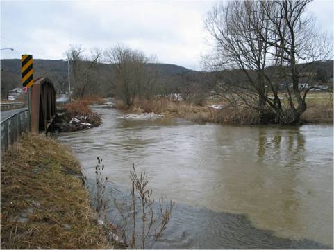
Document
evidence of the September 2011 Floods
in Delaware and Otsego counties, New York o
I have surveyed
several streams with a total station several years ago, and these recent
floods have made some noticeable changes to the channels. We need to document
the changes with differential GPS and total station surveys, and with stereophotographs.
There are several important themes in this research, including how erosive
the streams were for given peak discharges, particularly in bedrock reaches
of local streams. o
Float the local
streams, including the Unadilla, Butternut, Wharton, Otego, Cherry Valley,
Charlotte, Schenevus, and upper Susquehanna, compile GPS paths of the current
channels, and geotag scaled and oriented photos of
areas of erosion and deposition. This data in many cases can be compared to
recent historic data, but in addition, this survey provides a more
quantitative baseline for future surveys. We’ve had several storms in the
last decade that approach the flood of record, and
it seems likely we are in a phase of such stormy events. We need to
understand how these floods are affecting our drainages. o
Investigate flood heights and channel bed roughness
in Otsego County stream channels using a total station to map out flood
surfaces. ·
Work on flood
plains in Otsego County to identify
signs of flooding that could persist for longer times (10s of years or
longer), using tree rings and floodplain stratigraphy. We need longer flood
records, and this kind of research is waiting to be done for local streams!
We have soil and tree coring tools, and GPR to assist with subsurface
mapping. ·
Map stream reaches in Otsego County from a kayak with a GPS and camera. This project would greatly
assist with understanding the basic environmental settings at a reach scale
in local streams. Grain size patterns in the channel and how grain sizes vary
downstream will be characterized. ·
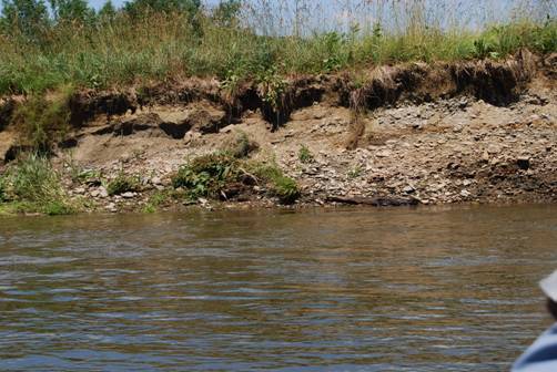
Map the location of cutbanks and the record of past stream activity as revealed
by deposits in channel cutbanks.
·
Using GIS,
investigate mountainous landscapes for evidence of migrating divides in drainage basins where fluvial and hillslope
processes dominate. This project would include the use of GIS, elevation,
geologic, and aerial imagery to test ideas of the controls on drainage
instability in eroding landscapes. ·
Explore the
relationships between rainfall and
runoff in central New York. ·
Investigate changes in landscapes using data
available for free from the USGS Seamless server, as well as from New York
State’s GIS clearinghouse. Numerous data layers that span a few decades are
now available. Comparing these data sets in a variety of settings will give
us a very direct measure of process activity, and how humans could better
utilize the landscape with this activity in mind. Along these same lines,
aerial photographs can be combined with elevation data sets in a GIS
environment to explore changes in the landscape. The projects would utilize GIS,
kinematic GPS, surveying tools, as well as observational skills. It’s a great
training ground for a broad spectrum disciplines! o
Active
landslides are one place to start. There are several in the area. A picture
of one appears below. o
Stream
locations are a great feature to monitor, particularly in valleys with
meandering rivers. A quick way to determine if the channel has changed
location is to float the stream
with a GPS unit, and compare the path to mapped locations of the stream in
the past. ·
Establish a
relationship between soil creep and
tree trunk curvature. o
This will
involve field work, surveying, and establishment of field sites for long term
monitoring of soil creep. o
Several State
Forests in the area provide excellent opportunities to investigate tree growth and soil movement. ·
Characterize glacial effects in the uplands of
central New York o
This could
involve exploration using elevation data sets and aerial imagery in a GIS, as
well as field investigations. o
We have a GPR (ground
penetrating radar), a shallow seismic tool, and a gravimeter to investigate
the subsurface beneath the curious landforms in the uplands. ·
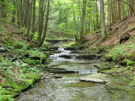
Map the bedrock gorges in our area, and begin
to work out why they occur where they do…
·
Construct a miniature eroding landscape model
which couples runoff erosion with uplift, and investigate drainage basin
development as a function of substrate resistance. You could replicate Grand
Canyon National Park! ·
Learn how to
use a handheld Raman spectrometer to
identify minerals, and extend our current library of mineral spectra ·
Create a shallow seismic depth meter to better
characterize shallow subsurface stratigraphy. This project would be perfect
for a physics-oriented person. We would like to mount this apparatus on a
cart, and use focused sound waves for shallow subsurface exploration. This
would be a joint project between Sunil Labroo in Physics and myself. ·
And of course,
if you have some ideas, I am happy to sponsor and assist you in your efforts |
|
|
|
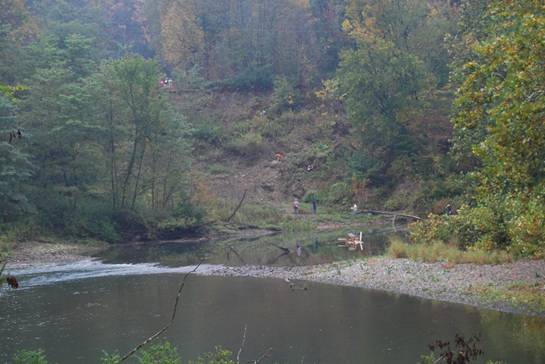
There’s
lot to work on geomorphically in this part of New York. Here’s an active
hillslope near Colliersville, NY, with the Susquehanna River chewing at its
toe. This landslide comprises numerous small slumps, flows, rock falls, and
creep, in varying stages of activity and recency. The substrate here consists
of poorly consolidated gravel and bedded sand units, whose surface forms a
terrace some height above the current river. Fine-grained units in the
hillside act as impermeable barriers to groundwater, and seeps are visible in
many places, especially at the toe of the landslide. This is strongly
suggestive that higher pore fluid pressures are acting to destabilize the
landslide. Indeed, liquefaction was apparent at the toe of the hillslope.
Note the student investigators for scale. |
|
Page maintained by Les
Hasbargen: hasbarle@oneonta.edu |