|
|
Ground
Penetrating Radar study of a Flood Plain The
Pine Lake Environmental Campus (Hartwick College) Charlotte
Creek in New York |
|
Overview Jump
to… GPR
Viewer (freeware GroundVision v2, from Mala Geoscience) Collaborators Cindy Klink, at SUNY Oneonta and Hartwick College Emmon Johnson, undergrad at SUNY Oneonta Pete Johnson (Emmon’s dad!) Renee Walker, at SUNY Oneonta David Anthony and Dori Brown, at
Hartwick College Les Hasbargen, at SUNY Oneonta SUNY Oneonta home |
In May 2008, a group of
faculty and students initiated a ground penetrating radar investigation at
Hartwick College’s Pine Lake
Campus. The area of interest rests on a flood plain between the kame
moraines which hold Pine Lake and Charlotte Creek. Archaeologists at SUNY
Oneonta and Hartwick College have excavated numerous artifacts (see this powerpoint
poster from Renee Walker, a professor at SUNY Oneonta, for the results of
field school excavations). The hope, going into this GPR mapping effort, was
to target locations for future excavations. For a great overview of how
GPR has been used in archaeological investigations, check out Lawrence Conyer’s site
at the University of Denver. Radar Solutions Inc has a nice overview of GPR here. And here
is a link to our recent poster
presentation at the Fall 2008 American Geophysical Union’s national
convention in San Francisco dealing with floodplain stratigraphy at Pine Lake. |
|
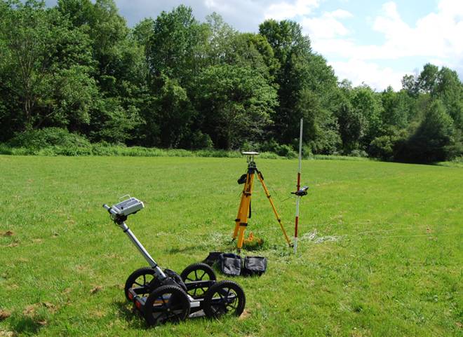
The
Tool SUNY
Oneonta purchased a Mala
Geoscience ground penetrating radar system in 2008. The system arrived with
500 and 100 MHz antennae. We utilize the 500 MHz antenna for mapping the
subsurface at Pine Lake.
As you can see in the image
above, the area is mown (easy to survey!), and low relief. A couple of
shallow (not visible) swales run the length of the field, which we interpret
as flood channels, and perhaps served as the main channel in the past. A
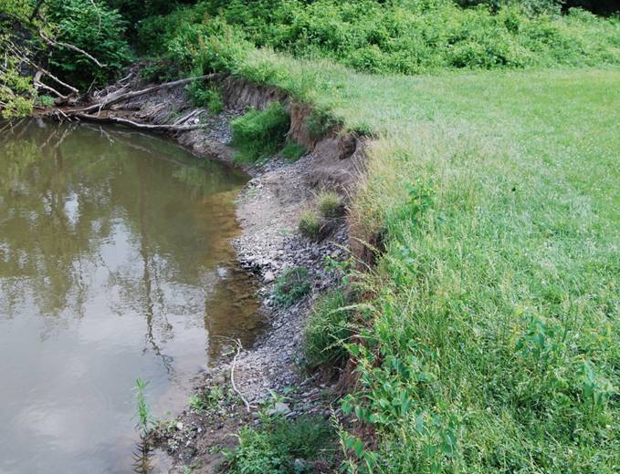
cutbank of Charlotte Creek bounds the east edge of the field (shown below),
and exposes a rounded cobble deposit underlying fine-grained sediments
(interpreted as channel lag or possibly a gravel bar overlain by floodplain
overbank deposits). |
|
|
Geomorphology |
Given this geomorphic
setting, what might we see in the shallow subsurface with GPR? Humans
occupied this floodplain back to about 4000 years ago, and perhaps longer.
Has Charlotte Creek migrated back and forth across this area in that time? Or
has this area been stable, with occasional floods draping silt and sand
lenses over the banks? Could we detect features left by humans, such as fire
pits and smoking platforms? This was our first experience
with GPR. We had high expectations for mapping subsurface features where
there was a large change in the radar transmitting capability of the
substratum. Clearly, gravel and fine-grained deposits should have
substantially different properties with respect to radar wave transmission.
Our initial plan was to perform a gridded survey at 1 meter spacing across
the entire field. Due to time constraints, we decided to collect a series of
parallel profiles across the floodplain, with each profile separated by 1
meter. Along each profile the GPR takes a “shot” roughly every cm. The maps
below provide a general setting.
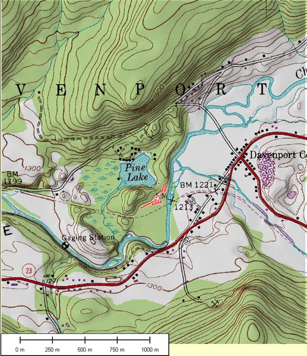
The
map above is part of a USGS Topo Quad (1:24K; contour interval = 20 feet)
wrapped onto a digital elevation model of the Pine Lake site. Red dots mark
previous small pit excavations, and they essentially map out the site at this
scale of observation. Dashed line just south of the excavations (north is up)
is an old railroad grade, now inactive. UTM projection. Overlay created in
Global Mapper.
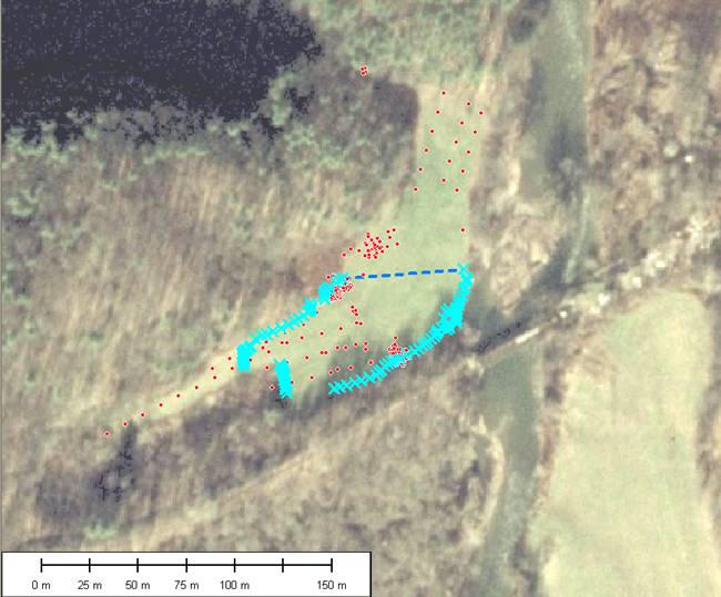
The
air photo (NAIP 1 m color data layer from the USGS Seamless server) above was
taken in 2005-2006 campaign, and shows the locations of excavations (red
dots) and endpoints of the GPR profiles (blue X’s). The dashed blue line
shows the orientation of GPR profiles. Pine Lake is the dark blue region in
the northwest corner (north is up). GPR profiles trend 084/264. UTM
projection. Overlay created in Global Mapper by Les Hasbargen. We processed the raw profiles
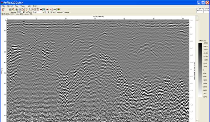
in a GPR profiling software called ReflexQuick2D.
The various filters applied to each profile include: Subtract-DC-shift;
Static correction; Subtract –mean (dewow); signal gain on return amplitudes
with depth; a bandpass filter; background removal; and a frequency-wave
number migration. Of these filters, the gain filter most affects
visualization of subsurface features. We found that the migration filter has
a rather small effect on depth location of features. We also roughly
calibrated the velocity of the subsurface as 0.024 m/ns (meters per
nanosecond), based on the depth to the cobble layer exposed in the cutbank. An example of a processed
profile appears below. For the map location of this profile, see the dashed
line in the map above. The approximate depth
(right-hand side axis) extends to 1.4 m. The horizontal scale is marked at 10
m intervals. This profile runs west to east across the middle of the field.
The dominant structure along this profile appears to be a mound in the
subsurface from 0.5-0.7 m depth. Other E-W profiles capture this same
feature, so it extends longitudinally (roughly north-south) for quite a
distance in the subsurface.
A compilation of GPR profiles
(south of dashed
line, north
of dashed line) for the field site is provided in these (rather large!!)
powerpoint files. Open at your own risk. |
|
Future work |
We have
begun the work of tying excavations into the specific profiles. Emmon
Johnson, a student in Earth Sciences at SUNY Oneonta, has created a software
that displays the profile image each time a user clicks on a map of the field
site—extremely useful software! One can readily view the subsurface radar
stratigraphy for all prior excavations, and target new features for further
investigation. We anticipate targeting the most-intriguing of the structures
for excavation in Summer 2009. Stay tuned for news and updates on this
project! |
|
Page maintained
by Les Hasbargen: hasbarle@oneonta.edu Page initiated July
12, 2008 |
|